
Water Resources in SW Wisconsin
This page is intended to provide basic information about surface and ground water resources in southwest Wisconsin and includes links to sources for additional information.
Groundwater in SW Wisconsin
What is groundwater and why is it important?
Some portion of the water that falls to the ground as precipitation (rain and snowmelt), seeps into the ground through pores in the soil and fractures in layers of rock. Water that is below the surface of the ground is groundwater. Some portion of groundwater will reach the water table as it seeps, or infiltrates down through the ground. The water table is the depth at which the soil and rocks are fully saturated with water (see the factsheet on Groundwater Recharge in the Additional Resources section). An aquifer is a layer of rock, gravel, or sand that can hold groundwater. Water wells are drilled into aquifers where enough groundwater occurs to provide a continuous supply of water for domestic or commercial purposes. In hilly areas, like SW Wisconsin, some groundwater flows downhill and seeps back to the surface at lower elevations through springs or directly into streams, rivers, and lakes through the stream bank or stream bed. This is why many small streams flow throughout the summer, even during periods of very low or no rainfall.
Groundwater is very important in SW Wisconsin because most water that is consumed in the region for drinking water and other domestic uses, livestock production, and industrial uses such as food processing, is groundwater that is pumped to the surface through a well that has been drilled through dozens or sometimes hundreds of feet of soil and rock. If you live in an urban area, your drinking water may come from a public well owned and operated by the local municipality. If you live in a rural area, your drinking water most likely comes from a private drinking water well located on your property. Unlike public water systems, private drinking water wells are not required to be tested for contaminants. Private well owners should test their well water for contaminants on a regular basis.
What affects the amount of groundwater?
There are many factors that influence the amount of groundwater that exists in a particular area at a given time, including precipitation patterns over time and local terrain. Two of the most important factors are the local soils and sub-soil geology. Soil types and geology vary greatly across the state and, at times, may even vary across a single field. Different soil types and geological formations vary in how easily they allow water to infiltrate down through the ground. For example, sandy soils allow water to pass through or infiltrate relatively quickly compared to clayey soils. Geological layers like fractured limestone and sandstone also allow water to infiltrate quickly, while shales generally do not allow water to infiltrate quickly.
If water is not able to pass quickly through a geological layer, it may accumulate above the impermeable layer, forming an aquifer. If you are drilling a well for water, you generally want to drill into a relatively permeable geological layer of either fractured rock or sand and gravel because you can pump more water and the water you remove from the aquifer will be replenished or recharged more easily. Much of SW Wisconsin sits on fractured sandstone and limestone, which makes it a good area for constructing groundwater wells. On the other hand, this same quality of quick recharge also means that contaminants on or near the surface can easily infiltrate or leach into the groundwater. This is why many private drinking water wells in SW Wisconsin have been found to contain contaminants like nitrate and bacteria.
What affects the quality of groundwater?
There are two main factors in determining the quality of groundwater – how quickly water can infiltrate from the surface into groundwater and the presence of contaminants. In SW Wisconsin, the soils and geology generally allow for relatively quick movement of water from the surface to groundwater and to aquifers that provide drinking water for most of our citizens. SW Wisconsin is also a very agricultural region with many livestock and dairy farms that apply manure to adjacent fields and crop fields where fertilizers and pesticides are often applied to improve productivity. Septic systems can be a source of contaminants (e.g., nitrate, chloride, pharmaceuticals) to groundwater and the risk of contamination increases when those systems are not maintained and when they are located too close to drinking water wells. Home septic systems should be inspected regularly and should be designed and located so as to minimize the risk of contaminating groundwater.
In general, the quality of drinking water that comes from a well depends on the quality of water in the aquifer that the well is drawing from. However, the quality of the construction of the well and the area around the well head can also affect water quality. Wells should be constructed to minimize the risk of contaminants getting directly into the well from the surface. Homeowners whose drinking water wells become contaminated may not be aware of the hazard because many contaminants like bacteria, nitrates, and arsenic do not affect the smell or taste of their water. Other contaminants like salts (often called brine) and sulfur that occur naturally in some aquifers affect the taste or smell of water but are not necessarily considered a health hazard. See below for more information on well water testing and ways to protect your drinking water well from contamination.
What is the quality of groundwater in SW Wisconsin?
In general, groundwater is considered to be a better source of drinking water than surface waters like lakes and rivers, because many contaminants are removed or broken down as surface water infiltrates through the soil and into an aquifer. However, for the reasons mentioned above, many drinking water wells in this region are at risk of contamination. Recent laboratory tests of samples taken from private drinking water wells in Iowa, Lafayette, Grant, and Green Counties have raised concerns about groundwater contamination. Nitrates and bacteria are the contaminants of greatest concern. Go to the SWIGG Study page on this site, the UW-Madison Extension Green County website, or the Wisconsin Well Water Viewer for more information on these private well testing studies and for information about having your well water tested.
Surface Water and Watershed Management in SW Wisconsin
What is surface water?
Surface water includes any water that falls as precipitation, including snowmelt, and flows over the ground. While all water that runs over or pools on top of the ground qualifies as such, generally when we talk about surface water, we’re referring to streams, rivers, lakes, and wetlands. Southwest Wisconsin is blessed with abundant surface water resources, especially streams and rivers, which support a wide variety of aquatic and terrestrial plants and animals that depend on surface water. The Wisconsin Department of Natural Resources (WDNR) estimates there are 88,000 miles of streams and rivers in the state. Some portion of surface water becomes groundwater when it soaks into the ground, and groundwater, in turn, can become surface water again if it seeps out of the ground as a spring or into a stream or river channel. As a result, the quality and quantity of our groundwater and surface waters are very closely related.
What is the quality of surface water in SW Wisconsin?
It’s difficult to make generalized statements about surface water quality across the region for several reasons. First, the Wisconsin Department of Natural Resources (WDNR) is responsible for monitoring and reporting on surface and groundwater quality in the state and they have limited resources to fulfill that obligation. Therefore, they have to prioritize where they will conduct that monitoring each year and many rivers, streams, and lakes do not get monitored for many years. For example, in 2018 over 40% of the state’s rivers could not be evaluated to determine if they meet state criteria for aquatic life because of a lack of data. Also, the methodology that WDNR uses for assessing the health of our surface waters is complex and multi-faceted. For example, they use one set of criteria to determine if a water body is safe for recreation and different criteria to determine if a water body is supporting healthy communities of fish and other aquatic life.
Nevertheless, it is possible to state that, overall, surface water quality has improved significantly in SW Wisconsin over the past 50 years, due in large part to regulations that have resulted in a significant reduction in pollutants being released from wastewater treatment plants and industries and also due to improvements in farming practices that have reduced soil erosion and runoff of fertilizers, pesticides, and manure from livestock operations, dairies, and cropland. Statewide, in 2018, WDNR reported that 82% of all surface water bodies that were assessed were healthy and 18% were impaired for recreation, aquatic life, or fish consumption.
However, much remains to be done to further reduce soil erosion, pollutant runoff, and to restore habitat that supports aquatic life. Many of SW Wisconsin’s rivers and streams have been designated as impaired by WDNR (see map, below), meaning they are not meeting some of the standards established by the state to support recreation, fish and aquatic life, public health and welfare, or wildlife.
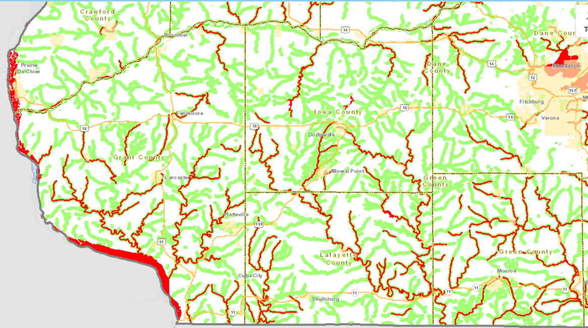
Map of SW Wisconsin showing assessed streams that are considered healthy (green) and streams designated as impaired (red) by Wisconsin DNR. Iowa County is in the top center of the map. This screenshot was taken from the WDNR Surface Water Data Viewer on April 24, 2020.
What are the major causes of water quality impairments?
The most common cause for a surface water body to be designated as impaired by WDNR is high concentrations of phosphorus. Phosphorus occurs naturally in soils and surface water, but high concentrations typically are caused by runoff of phosphorus from farmland, where it is applied to cropland and pasture as chemical fertilizer or as a component of manure. Phosphorus can also come from wastewater treatment plant discharges to rivers and streams. High phosphorus and other plant nutrients, like nitrogen, can cause excess algae growth in rivers and lakes. Nitrate, a form of nitrogen that is easily dissolved in water, are also a health hazard to humans at concentrations above 10 milligrams per liter. Other causes of surface water impairment are mercury, polychlorinated biphenyls (PCBs), sediment (caused by soil erosion), and bacteria from human and animal waste. Surface waters can also be impaired by channelization, which occurs when the natural course or shape of a river or stream is altered in order to accommodate some land use. For example, many rivers and streams were dammed in the past to pool water for industry or recreation and many streams have also been straightened and widened to make flood-prone areas more suitable for development and agriculture. Altering stream channels can also remove critical habitat for fish and other aquatic life.
What is being done to improve the quality of our surface water?
Much progress has been made to improve the quality of surface water around the United States since passage of the federal Clean Water Act in 1972. Pollutants from industries and wastewater treatment plants, in particular, have been greatly reduced since the 1960’s. However, much work still remains to be done to reduce the impacts of land use on water quality. In most urban areas, local governments are required to demonstrate that they are taking steps to prevent contaminants from running off lawns, streets, and other paved surfaces into storm sewers, rivers, and streams. In agricultural areas, farmers and landowners are encouraged to adopt best management practices (BMPs) that reduce soil erosion and runoff of fertilizers, pesticides, and manure into drainage channels, rivers, and streams. While most BMPs are voluntary, over the past 20 years, the federal government and State of Wisconsin have adopted some regulations that require certain practices to reduce the risk of manure and agricultural chemicals like fertilizers from leaving the farm and contaminating surface water.
What is a watershed and what is watershed management?
Water flows downhill and as it flows downhill it gathers into small streams and, eventually, rivers. All the land that collects water that flows into a stream or lake is referred to as the watershed for that lake or stream. As you might expect, small streams have small watersheds and large rivers, like the Wisconsin River have very large watersheds. The large watersheds can be subdivided into many small watersheds (sometimes referred to as sub-watersheds) in the same way that a county can be sub-divided into townships. Watersheds are important because what happens on the land that drains into our rivers and streams and lakes greatly affects the quality of the water in those surface water bodies.
Watershed management is an approach to managing water quality in our rivers, streams, lakes and reservoirs by looking at land use throughout the watershed and identifying ways to manage the land in ways that minimize the impact on water quality. For example, in urban areas, watershed management might involve looking for ways to reduce pollutant runoff from paved surfaces and fertilizer runoff from lawns. In agricultural areas, watershed management might involve looking for ways to reduce soil erosion and manure runoff from cropland and pastures. Governments, organizations, and individuals have to work together for watershed management to be effective because many different individuals and entities are involved in making land use decisions.
What are farmers doing to improve water quality in SW Wisconsin?
In southwest Wisconsin, most of the actively managed land in our watersheds is farmland. Therefore, farmers and farmland owners have an important role to play in protecting and improving water quality. Many farmers implement best management practices on their farms to reduce soil erosion and to minimize the risk of fertilizers, pesticides, and manure contaminating surface and groundwater. In some watersheds, farmers have organized to form producer-led watershed councils. The State of Wisconsin and UW-Madison Extension support these watershed councils as a way to encourage farmers to work together collaboratively with each other and with state and local governments and non-profit organizations to protect and improve water quality in their watersheds. Producer-led watershed councils seek to reduce the impact of agriculture on water resources through education, sharing information about best management practices, and creating a sense of shared responsibility for protecting those resources for current and future generations.
Additional Resources
Groundwater
- The Central Wisconsin Groundwater Center is a part of the UW-Madison Department of Extension and is housed at UW-Stevens Point. Their website has a number of video presentations and reports on groundwater and well water quality.
- The Water and Environmental Analysis Lab at UW-Stevens Point will analyze samples from private drinking water wells for contaminants.
- Groundwater in Iowa County: A Citizen’s Guide is an excellent resource for learning the basic science of groundwater. While the guide was created specifically for Iowa County, much of the information is relevant to other counties in the region.
- The Wisconsin Geological and Natural History Survey website has information about Wisconsin aquifers, drinking water quality, groundwater level monitoring, sinkholes, springs, and well records. You can also view maps of aquifer yield (how many gallons of water can be pumped from a given well per minute), recharge rates, and depth to the water table.
Surface water
- A great deal of information can be accessed from the Wisconsin Department of Natural Resources’ Surface Water landing page, including information about Wisconsin’s water quality standards, water quality reports, and WDNR programs aimed at assessing and protecting surface water quality and habitat.
- The Wisconsin Department of Natural Resources Surface Water Data Viewer is an online tool for accessing and viewing water quality data collected across the state of Wisconsin.
- PDF files of the State of Wisconsin’s bi-annual Water Quality Report to Congress can be downloaded from the WDNR website.
- The University of Wisconsin – Madison Extension Lakes Program works with lake associations and lake districts to preserve Wisconsin’s lakes through education, communication and collaboration. They also offer a variety of programs, like the Water Action Volunteers Stream Monitoring Network that trains private citizens to monitor water quality in their area.
Watershed management and farmer-led watershed councils
- WDNR’s Gateway to Wisconsin’s basins and watersheds provides an interactive map of Wisconsin’s major watersheds (also called ‘basins’). Click on your basin to learn more about watersheds and water quality in your area.
- Learn more about Producer-Led (farmer-led) Watershed Councils funded by the Department of Agriculture, Trade and Consumer Protection.
- Learn more about the Iowa County Uplands farmer-led watershed group.
- Learn more about Farmers of the Sugar River watershed group in Green, Rock, and Dane Counties.